
This story is part of Worthington Pulse's coverage of the October 19 City Council meeting. Start with the October 19 meeting recap.
City Council adopted the Worthington Together Comprehensive Plan Monday night by voice vote with no dissent, ending a two-year process that began when council approved the consultants' scope of work on October 7, 2024 (Resolution 59-2026). The plan sets a long-range vision for land use, transportation and development across the city, including an updated thoroughfare plan and a list of actions with suggested timing. It does not rezone any property. The work that will change what can be built, a rewrite of a zoning code that dates to 1971, starts now and is funded in the proposed 2027 budget.
What was adopted
Planning and Building Director Lee Brown noted the timing: October is National Community Planning Month, and the vote came exactly 24 months after council approved the project. An 18-member community committee appointed in January 2025 met 11 times over the process, and the Municipal Planning Commission recommended approval on September 24 after two hearings of its own since the July 6 joint session with council.
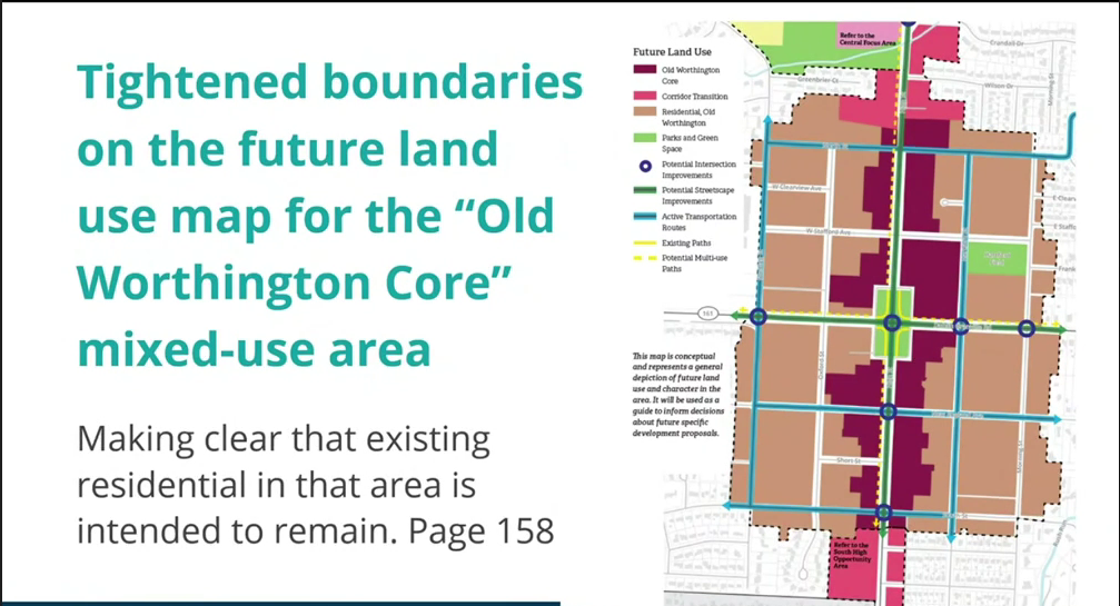 Consultant Michael Curtis of planning NEXT showed how the Old Worthington core boundaries were redrawn since July. From the video at 1:52:45.
Consultants Jamie Greene and Michael Curtis of planning NEXT walked council through what changed since July. The full plan now opens with a 15-page executive summary that points readers to specific pages in the larger document, and the summary is also available on its own. The substantive changes, Curtis said, were refinements rather than reversals:
- Linworth is now an opportunity area, with direction to coordinate with the neighboring jurisdictions, complete the corridor for walking and biking, establish a western gateway into the city, and keep the existing residential character. The commercial footprint shown is the one that exists today.
- The Old Worthington core was redrawn on the future land-use map to follow existing zoning more closely, after the Planning Commission asked for clear boundaries so residential areas are not shown converting to other uses.
- "Historic character" got a clearer definition on page 41 of the land-use chapter, and the Linworth stretch of the street typology map was corrected from a residential boulevard to a mixed-use boulevard.
- Street sections now say street trees are preferred wherever space allows, and population figures and park maps were made consistent throughout.
A track-changes version showing every edit since July is posted on the project website, worthingtontogether.org.
Two objections from residents
Five residents spoke. Two asked council not to adopt the plan as written.
One argued the plan has no serious assessment of how the development it envisions would affect traffic congestion, which he called "an unacceptable omission." He pointed out that the plan's first strategic priority is a comprehensive rezoning while its treatment of congestion amounts to one section on preparing High Street and Route 161 for higher-capacity transit, and said neither the plan nor a rezoning should be approved without a traffic analysis.
Council Member Rebecca Hermann answered that the city already requires a traffic study for every development, that the High Street and Wilson Bridge corridors are under study now, and that congestion is too dynamic to pin down in a 20-year document: "I don't think I've personally ever seen traffic in the comprehensive plans that I've read." Greene agreed that the plan analyzes conditions and recommends mobility improvements, but that engineering specific intersections is not what a comprehensive plan does. He added that traffic impact standards belong in the zoning code assessment the city is about to start.
A second resident objected to the West Wilson Bridge Road opportunity area between Old Wilson Bridge Road and the Olentangy Parklands, shown on page 138 as a mix of "mixed-use core" and "mixed-use edge." He called it the most transformative recommendation in the plan, said buildings up to 10 stories next to quiet neighborhoods like Olentangy Hills are "simply inappropriate," and asked council to amend the plan to follow the 2011 Wilson Bridge Corridor Study and the 2016 zoning that implemented it, which he said would allow three- to four-story mixed-use buildings instead. Council did not take up the amendment.
The other three speakers supported the plan, and all three tied it to housing. A 27-year-old who moved back to Worthington after law school said he cannot afford to leave his parents' house and that the city "can't just be affluent 40-plus landowners." A second speaker, who works for Worthington Steel and said the company is moving its headquarters from Wilson Bridge Road to Easton, said the area around the current headquarters is "surrounded by nothing of value" and that higher density is the only way to bring rents down. A third, a retiree, spoke in favor of the plan, using her own street—where only two of 14 homes have children—as a 'troubling' example of the city’s demographic imbalance. While she admitted to initial nerves regarding previous growth—such as the community center expansion and the East Wilson Bridge apartments—she argued those projects ultimately enhanced the city. Pointing to the Methodist Children’s Home site, which has remained vacant for 16 years, she warned that if development isn't prioritized soon, 'composting is the least of your problems.'
Stay connected to what's happening in Worthington, Ohio.
What council asked
Council Member Maria Ramirez asked how the Planning Commission's request to reinforce the city's gateways landed in the plan. Brown said entry features are discussed in the Linworth and South High Street opportunity areas, the approaches from Clintonville and from I-270 at Wilson Bridge Road, and that staff can add smaller touches like bridge signage or planters outside the plan itself. Curtis pointed to a paragraph at the start of the opportunity-areas chapter, page 135, saying several of those areas serve as gateways and should signal arrival through building placement, landscaping, lighting and signage.
Council Member Pete Bucher asked what happens next. City Manager Robyn Stewart said the plan's implementation chapter sorts its actions into immediate, short, medium and long term, and that the piece tying most of them together is the planning and zoning code rewrite. This year's budget paid for an outline of what needs to change; the proposed 2027 budget includes money to carry the rewrite through, likely in waves rather than a single document, over the next year or more.
The zoning rewrite, and a Northeast-side test case
Brown said the city's zoning code was written mostly in 1971 and, despite 55 years of amendments, "still is antiquated." Most zoning will not change in substance, he said; names, standards and setbacks will be updated and the code will lean heavily on design standards and graphics so expectations are clear to everyone.
The first district to get that treatment is the Northeast area, the industrial corridor along Huntley, Schrock and Proprietors roads that the city has branded Forge Fields at Rush Run. Brown said he and Planning Coordinator Lynda Bitar have worked for the past year with NBBJ, the firm that wrote the original Northeast Area Plan, on draft code language for new districts there, and the plan is to bring council the text and then rezone the corridor to match. He called it the "guinea pig" for how design standards will be laid out in the full rewrite. He expects to bring it to council for comments at the January meetings rather than by year's end.
Council President Rachael Dorothy said she had sent staff a list of typographical fixes to incorporate and that the city will keep working with COTA toward frequent bus rapid transit on High Street and Route 161.
The adopted plan and executive summary are posted at worthingtontogether.org and on the city's Worthington Together page.
This is one of 3 Worthington Pulse stories from the October 19 city council meeting recap.