
Hello Worthington! Here's your recap of what happened at November 5's Board of Zoning Appeals meeting. Below are summaries of the commercial and institutional projects that directly impact our community.
Only one item on this month's agenda fits the above description: the city's plan to repave the Olentangy Trail. The rest of the agenda was five variance requests for single-family homes: a replacement garage, a fence, a new house that sits 30 inches into its front setback, and two basement egress windows. The board approved all five unanimously.
Olentangy Trail Repaving Clears a Floodplain Hurdle
The Board of Zoning Appeals voted 5-0 to let the city add fill in the Olentangy River floodplain, clearing one of three approvals the city needs to repave the Olentangy Trail next year. The project would resurface the whole trail inside city limits, plus the spur paths around the playgrounds, and, if money allows, rebuild two turns where trail users have trouble and move one stretch away from a stand of mature sycamores. The city plans to put the work out to bid in late November or early December, with construction running from spring through summer 2027.
Why repaving needs a variance
Director and City Engineer John Moorehead, who presented the request, told the board that floodplain variances are "not that common" at the BZA, because little gets built in the floodplain along the river. But nearly all of the trail sits in it.
Under federal rules, the city could mill out old asphalt and lay down the same amount of new asphalt without any special approval. This project goes further. In some places the city plans to lay about an inch and a half of new asphalt over the existing path, and in others to build new sections of trail. Both add material to the floodplain, and that counts as fill.
Whether that fill is allowed depends on where it goes, and the rules divide the river valley into two zones. The 100-year floodplain is all the land that would be underwater in a flood with a 1% chance of happening in any given year. The floodway is the middle of it: the river itself plus the land right beside it, where a flood carries the most water and moves fastest. The rest of the floodplain, called the flood fringe, floods with slower water. In the Olentangy Parklands, the gentle slope down from the neighborhoods is roughly the fringe, and the flat ground below is about where the floodway begins.
Federal rules only restrict the floodway: FEMA doesn't allow any fill there unless a study shows it won't raise flood levels. Worthington's code goes further and doesn't allow fill anywhere in the floodplain without a variance. "Worthington's standard is that you can't fill the flood plain. FEMA's standard is you can't fill the floodway," Moorehead said.
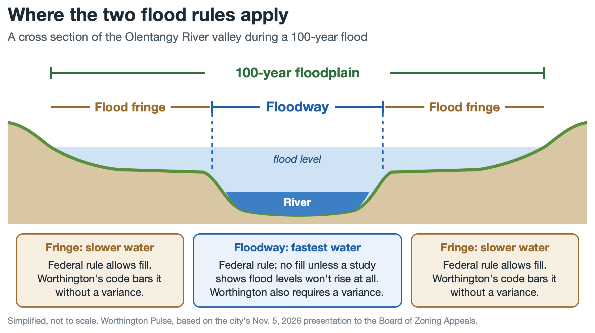 Federal rules limit fill only in the floodway; Worthington's code covers the whole 100-year floodplain.
Stay connected to what's happening in Worthington, Ohio.
Showing "no rise"
Because some of the work is in the floodway, the city had to prove it won't raise flood levels at all, not even by a hundredth of a foot: "0.00 feet of change in the floodplain, or we can't do this," Moorehead said. To check, city engineers took the computer model the river's flood maps are based on, raised the ground one to four inches where the trail work is planned, and ran a simulated 100-year flood again. The predicted flood level came out the same. "Spoiler alert, it shows that there's no rise," Moorehead said. Floodwater crossing the parklands moves at two feet per second or less, so a slightly higher trail barely affects it.
A board member who once needed Army Corps approval to renovate a house on the river asked whether this project would need federal review too. Because the model showed no rise, Moorehead said, the city "does not have to seek approval through FEMA or the Army Corps of Engineers."
Three optional fixes
When the city puts the project out to bid, the main job is resurfacing. Bidders will also price three optional pieces of work separately, which the city would add "if funding allows." The city asked for the variance to cover them too, so the approval is in place if they get funded.
- The SR-161 hill. Riders heading north from Antrim Lake into Worthington come down a slope into an abrupt, roughly 180-degree turn. The city would shift that intersection south to ease the slope and give cyclists and runners more room to stop. "This is a safety improvement," Moorehead said. Building up the ramp where the trail runs out into Galipault Field takes fill.
- The Tucker Bridge bend. Northbound users coming off the bridge near Tucker Drive drop in elevation and hit a turn of about 90 degrees. Moorehead called it "the site of several people losing their footing or losing their traction on a cycle and ending up off in the grass there." The city would smooth the curve and route it between existing trees so people can see oncoming traffic. The same option would pave the mulch connector from the end of Tucker Drive to the trail. Bikes aren't allowed on the parklands' mulch trails, but cyclists still use that connector, which leads to conflicts with other trail users. The bridge itself is one of two aging timber spans on the trail that the city has separately applied for federal funds to replace.
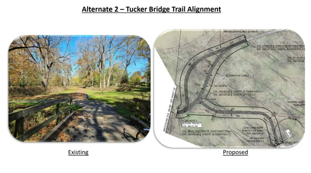 The bend off the bridge near Tucker Drive today (left) and the city's plan for a smoother curve (right). From the video at 19:16.
- The sycamores. One stretch of trail runs so close to a stand of mature sycamores that their roots are pushing up under it, and cutting roots that big could hurt the trees. The city would move that stretch a short way into the grass and dig out an equal amount of soil nearby to offset the new fill.
What comes next
The variance is the first of three steps. City Council still has to approve a grading plan for the digging part of the work. As Moorehead put it, council handles "digging in the floodplain," while the zoning board handles "putting dirt or anything else in the floodplain." After that, the city manager would issue a floodplain development permit.
The contract will limit how long the trail can be closed, and detours will be posted. City staff will present the project to council in more detail, and once a contractor is hired, the city plans to tell residents what to expect through signs on the trail and on social media.
Upcoming Dates
- Thursday, November 12 — Architectural Review Board and Municipal Planning Commission, Worthington Municipal Building. The agenda includes the city's request to demolish the 1926 house at 5995 Linworth Road, which it bought in September to add to Linworth Park. Agenda here
- Monday, November 16 — Worthington City Council, Worthington Municipal Building.
- Tuesday, November 17 — Parks & Recreation Commission, Worthington Community Center, 345 E. Wilson Bridge Road.
Was this recap useful? Forward it to a neighbor who'd want to know what's happening in Worthington — word of mouth is how the Pulse grows.
Thanks for reading this summary of the Board of Zoning Appeals meeting. You can watch the original full video here
Note: This recap focuses on commercial and institutional projects that affect the broader community. Individual homeowner applications, while important to those involved, are not included in this community newsletter.